Finding the Changing Boundaries of Counties
 When attempting to narrow down hometowns for our ancestors you will quickly see that some towns no longer exist, were incorporated into another town, had a name change or is now part of a different county. When looking about the name and location of a county, it is boundaries that have changed the most over the decades within the United States.
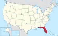
An example is the Dade County, Florida which today most people associate with the lower southeast corner centered around Miami, Florida. Yet, you can go back to the 1890s and Dade County included land, towns and residences running up the Florida east coast for some 150 miles. Those boundaries slowly decreased as portions broke off to create a new county.
Using the Atlas of Historical County Boundaries done by the Newberry Library, researchers now have an excellent online database to use in determining what a county was named and what it included as any given time. With the United States map you can click on a state. You immediately have a series of links with information about that states and its counties.
It is best to start with the ‘Index of Counties’ for a selected state. Here the county names are listed, including names no longer in existence. There will be marked name of places ‘proposed’ as counties which never achieve that status. Here is also be a timeline of events and what changes occurred within that county. It is fascinating to see what some of the earlier names for counties were. An example is Orange County in Florida, home to the city of Orlando and Walt Disney World. For several decades in the early 1800s it was known originally as ‘Mosquito County’. Aren’t we glad that was changed?
There is the link for ‘Chronology of State and County Boundaries’ with a more detailed history of various regions and counties in the state. There is also the Dakota Territory which had 28 counties and can prove to be of great help to researchers in that region.
One of the best links is the ‘Interactive Map’. Here will be the historical map of that state and its counties going back to 1763 and coming toward to the year 2000. You can select what time period you wish to view on the map. It will outline the counties at that era and compare it to the modern-day location and name. A special note to view these very detailed maps it is recommended you use Internet Explorer 5.0 or above or Mozilla Firefox browsers and set the resolution of computer screen display to 1024 x 768 pixels for optimum viewing. The site does have a useful ‘Help’ section to assist in using the maps.
There is plenty to explore with this online source.
< Return To Blog Hi I located your blog by mistake when i searched Bing for this matter, I need to express your webpage is quite helpful I also seriously like the style, its awesome!Gaynelle 20/01/12
Where exactly is the facebook like button ?
Moshe 20/01/12
On the FamilyTree.com home page to the left is about the Facebook page. Under it is 'like' where you can click to like the FamilyTree.com Facebook. Or click on Facebook link for FamilyTree.com and you can 'like' the link there. Thanks for reading the FamilyTree site and blog -- tell family and friends.
alice 20/01/12
I loved your blog.Really thank you! Awesome.
seo 20/01/12
Awesome blog article. Will read on...
Leave a Reply